מתוך עמוד ענן
34.559464025897
31.505454225721Yes 112 מ'
תקציר
סגור
הרחבה
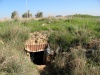
סיווג: אחר - אחר
נגישות:
מקור:Ilafer, היסטוריה על המפה, Schuster1996
תאריך עדכון: 6/15/2024 05:00:38
קישורים חיצוניים

 IMG 0004.JPG, IMG 0003.JPG, מועצה כחול.JPG, 2024-06-15T08_10_11.595943170456.jpg
{{{Csrc}}}
635276360632843532
PointDetails


